


Google Earth is used when you want to explore rich geographical content, want to see satellite images, maps, landscapes, 3D buildings or view satellite images from galaxies in outer space. It also lets you search the whole planet within seconds without requiring you to leave your comfortable room. You can search for anything on this planet whether it is a building, a landscape or anything else, Google Earth will help you. In this post we have collected some bizarre and interesting Google Earth photos, we hope they will impress you.
Just so you know
Sign up for a free Jotform account to create powerful online forms in minutes — with no coding required.
Google Earth Photos
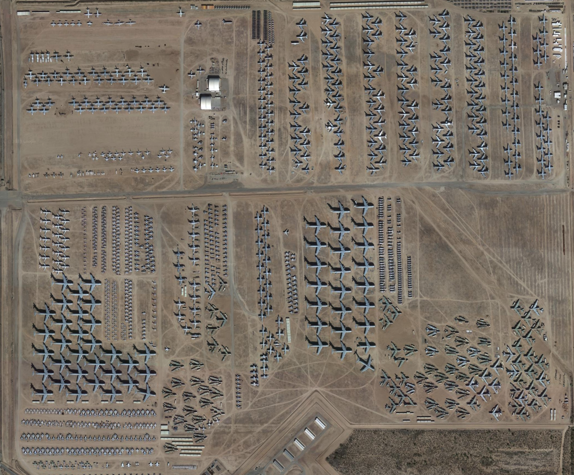
The Boneyard
The Boneyard is the largest plane cemetery located in Tuscon, Arizona. The site’s massive size is equal to an astounding 1,430 football fields, providing ample space for the extensive collection of over 4,000 retired aircraft.
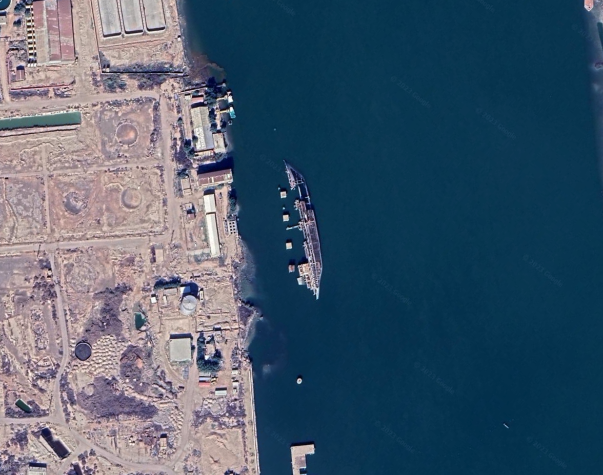
Shipwreck in Iraq
In the waters of Basrah in Iraq, a ship is afloat in a sideways position.
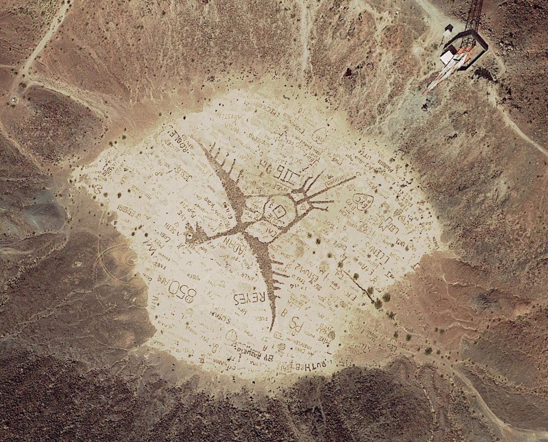
Graffiti in Google Maps
Site of an extinct volcano crater, the Cerro Prieto, located near Mexicali in Baja California (Mexico). Apparently, a lot of visitors to the site have decorated it with their graffiti, drawn huge enough to be seen from high above. The graffiti appears to have been drawn with the intention to be seen by people looking down into the crater from the eastern rim of the crater. Here’s a closeup shot of it, taken from the ground.
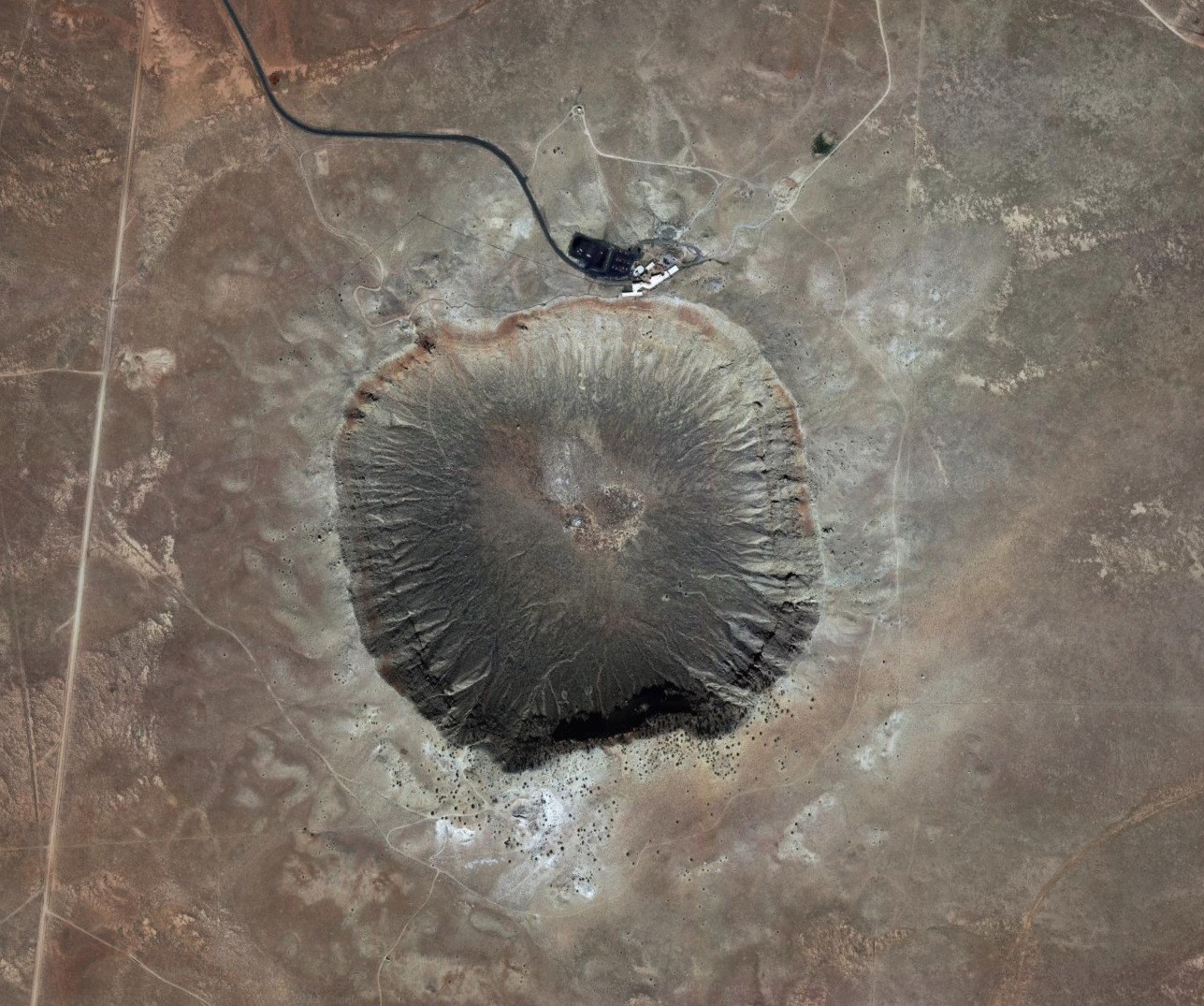
Meteor Crater
The Barringer Meteor Crater is a large impact crater located in northern Arizona, formed approximately 50,000 years ago when an asteroid or comet collided with the Earth’s surface, and is recognized as one of the best-preserved impact craters on Earth.
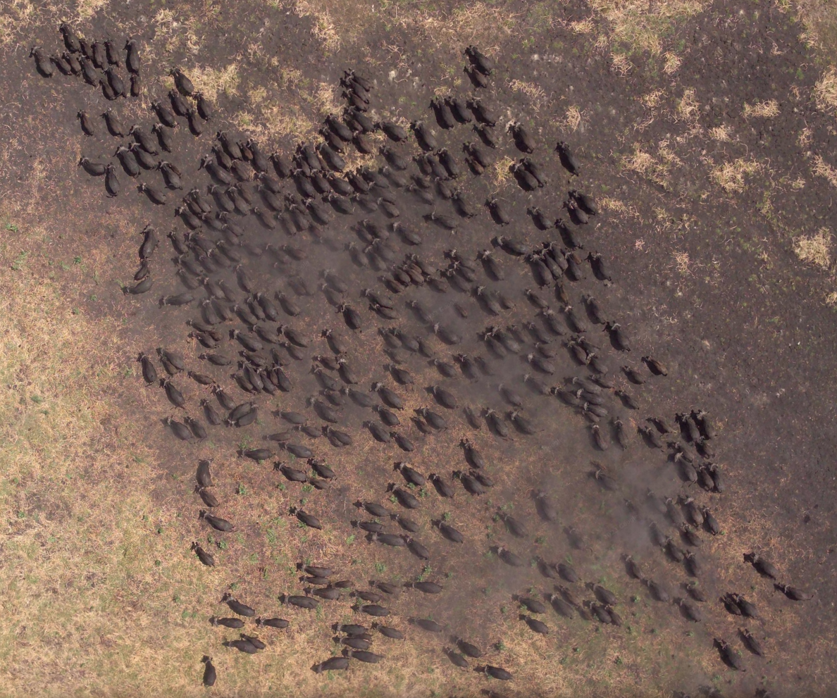
Buffalo Herd
Did you think it was unlikely to witness a group of buffalos roaming freely in their natural habitat? Fortunately, some satellite images have been taken of a herd in motion in the Moyowosi River in Tanzania.
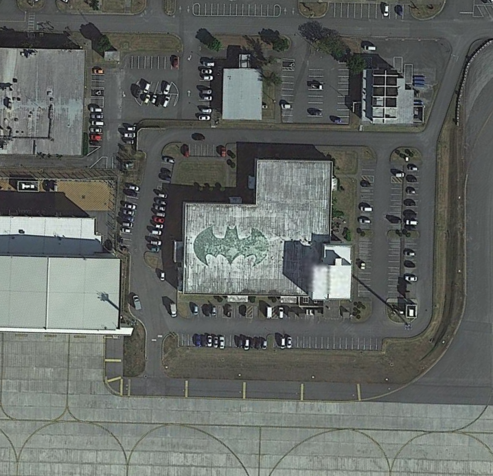
Batman Symbol Spotted in Okinawa, Japan
The Largest Coca-Cola Logo in the World
An advertisement made up of 70,000 empty Coca-Cola bottles in Chile is visible only from above.
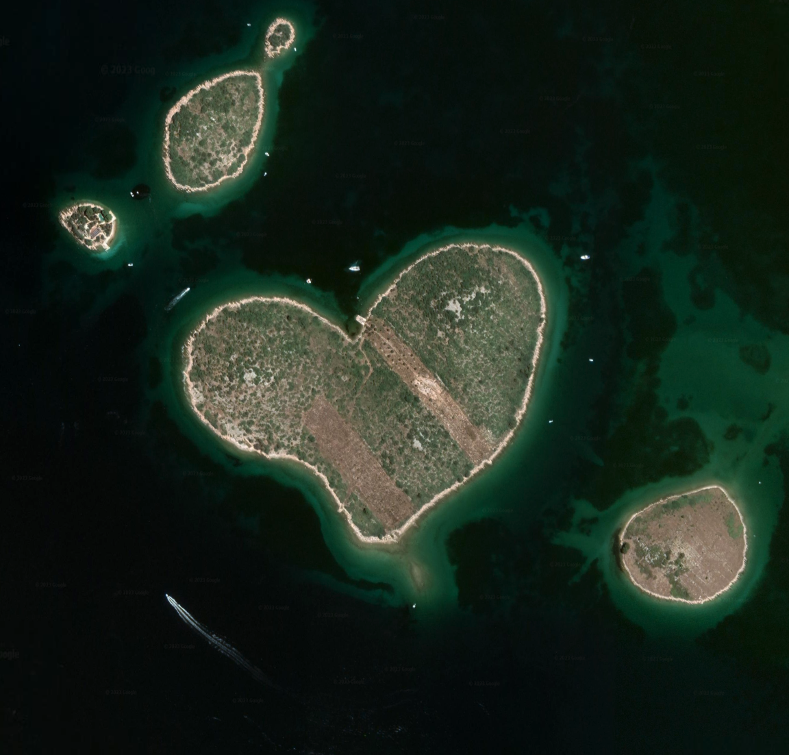
Heart-shaped island highlighted by Google Earth becomes hit with lovers
The 130,000 square yard islet of Galesnjak came to prominence after its unusual shape was highlighted on Google Earth.
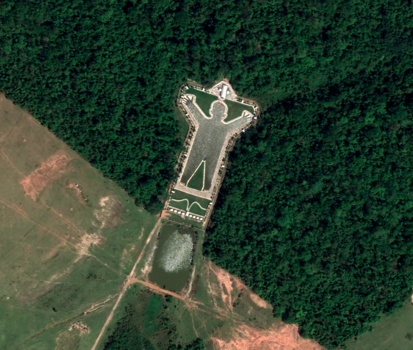
Man-Shaped Lake in Brazil
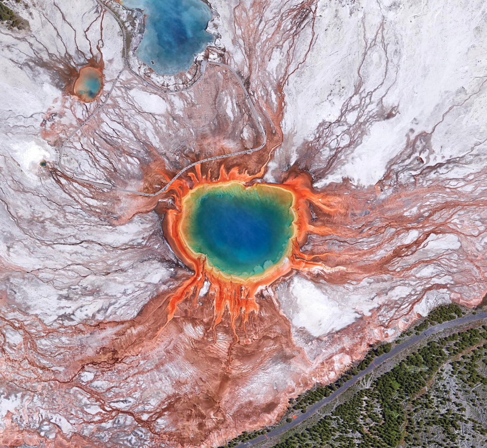
Grand Prismatic Spring at Yellowstone National Park
A giant, bubbling rainbow potion with vivid hues of red, orange, yellow, green, and blue.
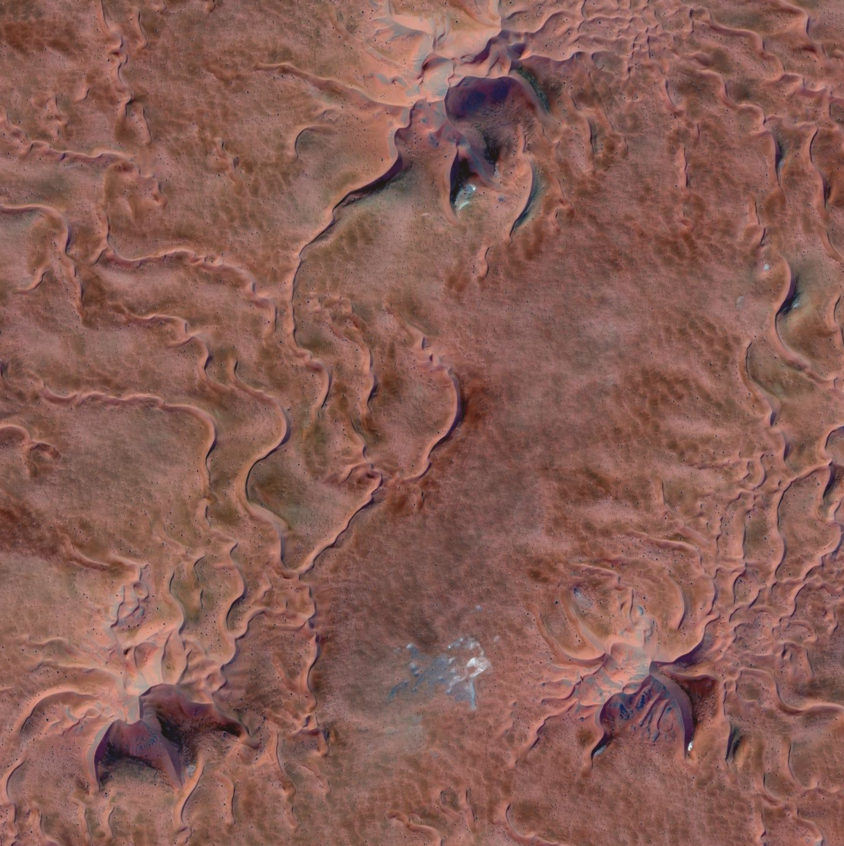
Issaouane Erg desert – Dunes (Algeria)
The shapes and colors of the dunes in this desert are amazing. Notice that the three dunes have almost identical shapes. And there are tens of thousands just like those all around.
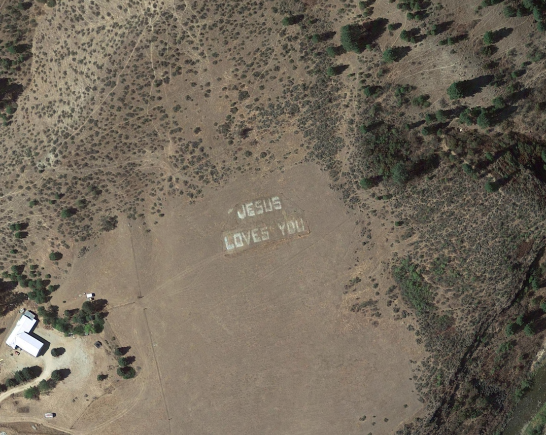
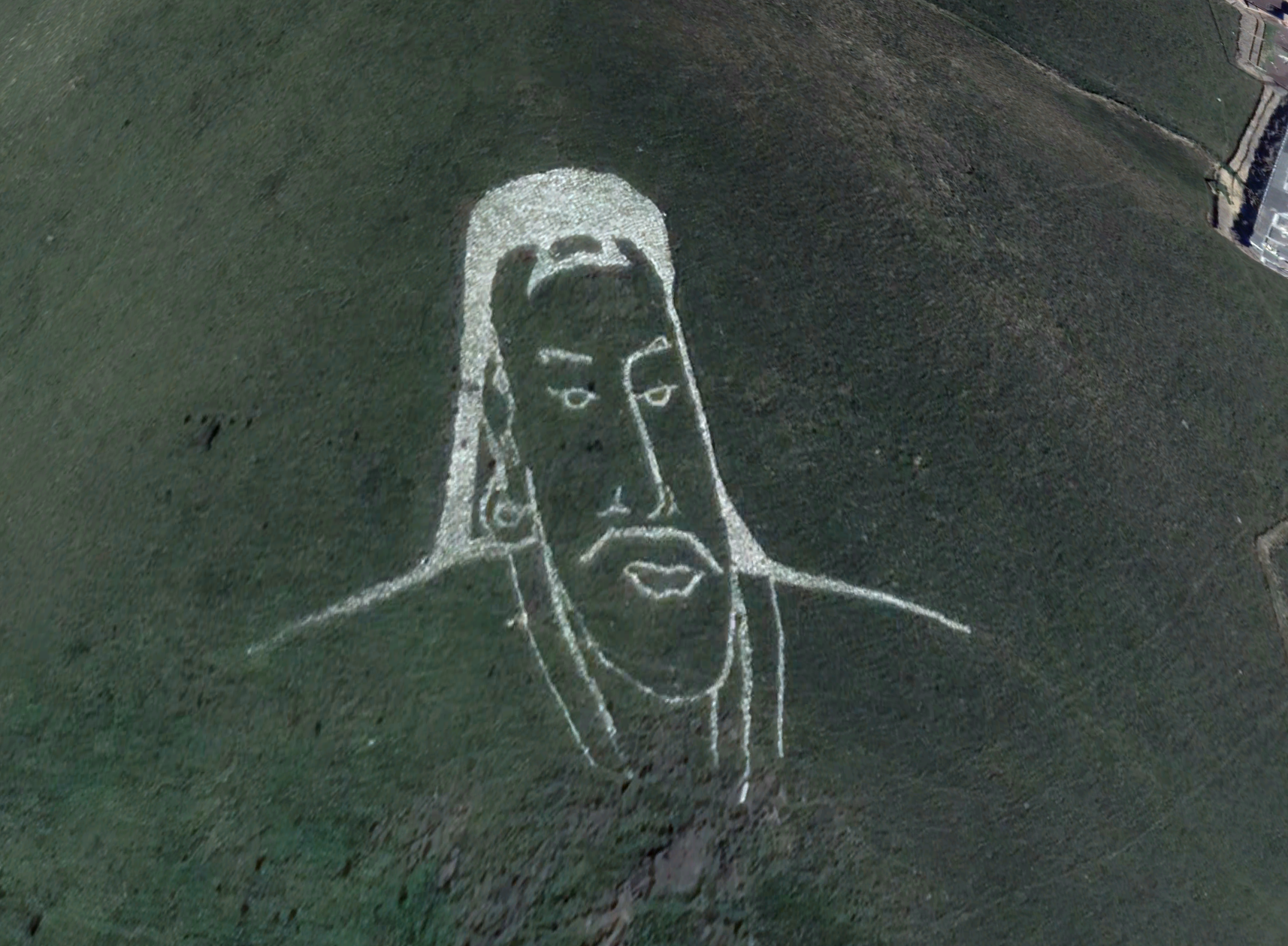
Jesus Loves You in Idaho
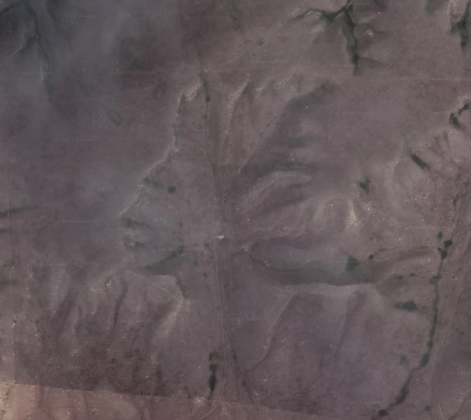
Terrain Face in Google Maps
The terrain in Alberta, Canada accidentally forms what looks like a human face when viewed from the air or when viewing the satellite pic in Google Maps.
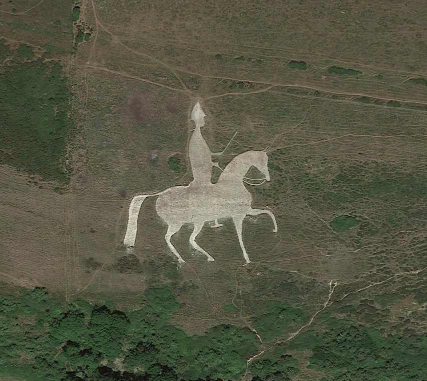
Osmington White Horse
The Osmington White Horse, outside Sutton Poyntz, UK. This prehistoric figure is carved into the white chalk of the hillside – such horse carved shapes are called “Leucippotomy”.
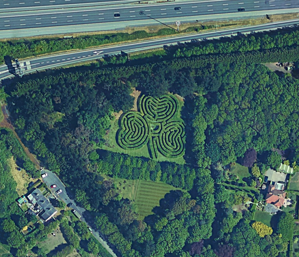
Lucky Maze in Dublin
A shamrock maze near the Dublin airport.
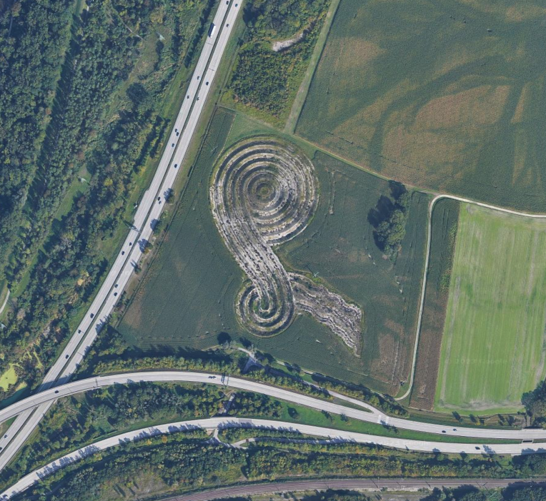
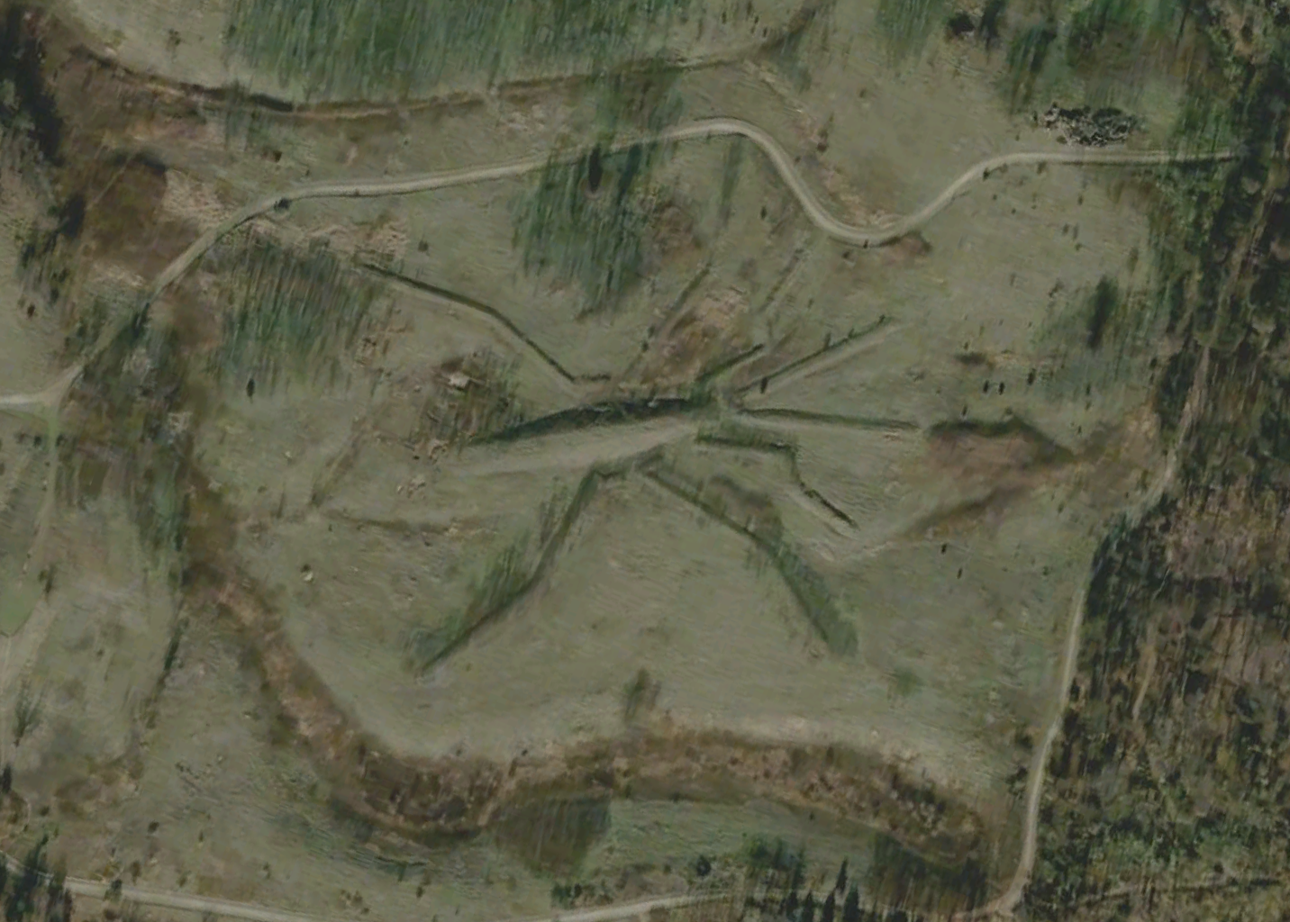
Land Art near Munich Airport
Land Art or “Earth Art” appearing in a field near the airport in Munich, Germany.
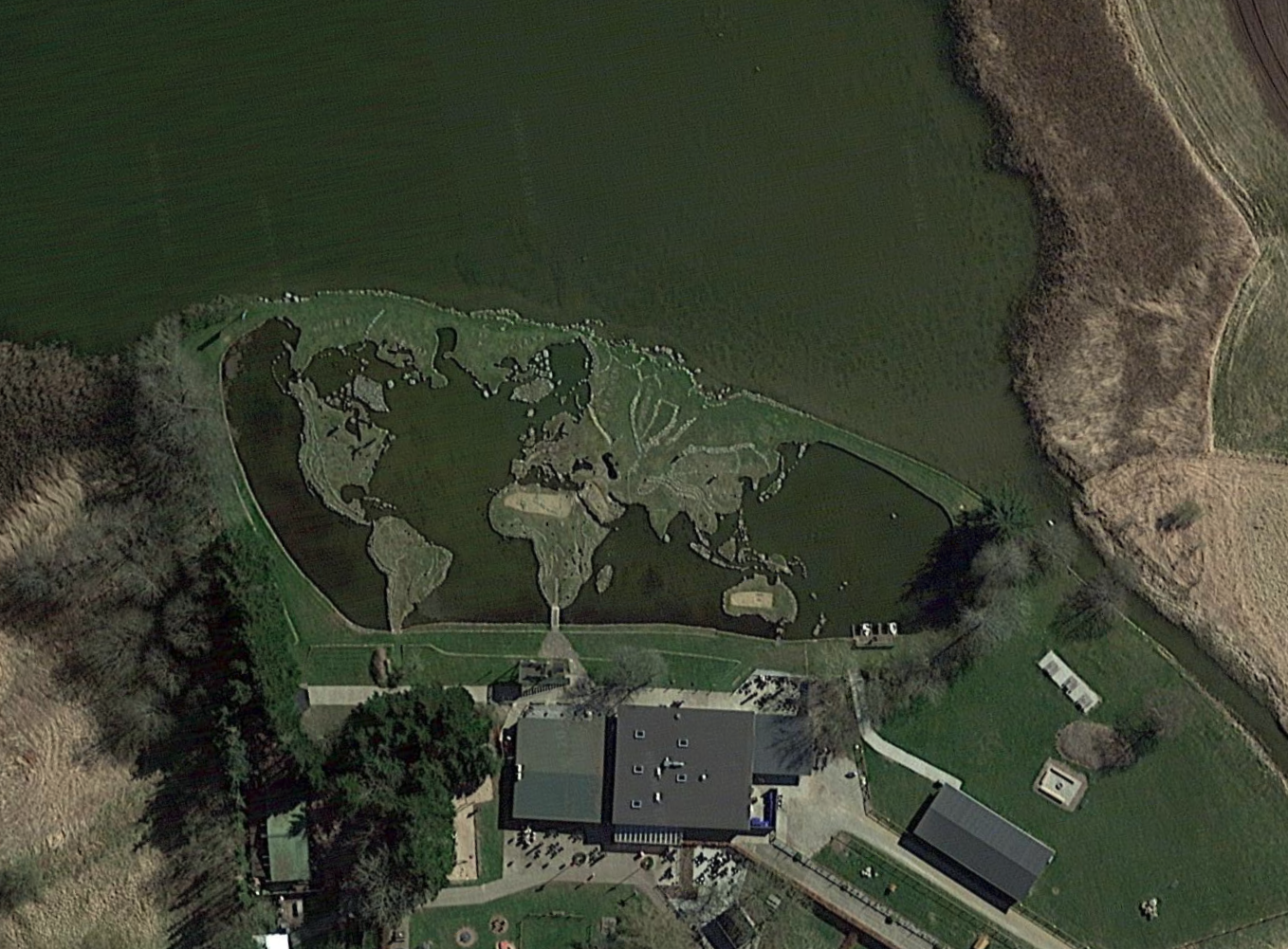
World Map in Denmark
The artist Søren Poulsen crafted this impressive world map between 1944 and 1967 by hauling stones with a sled on the ice during winter and carefully positioning them during the thaw, resulting in a stunning work of art.
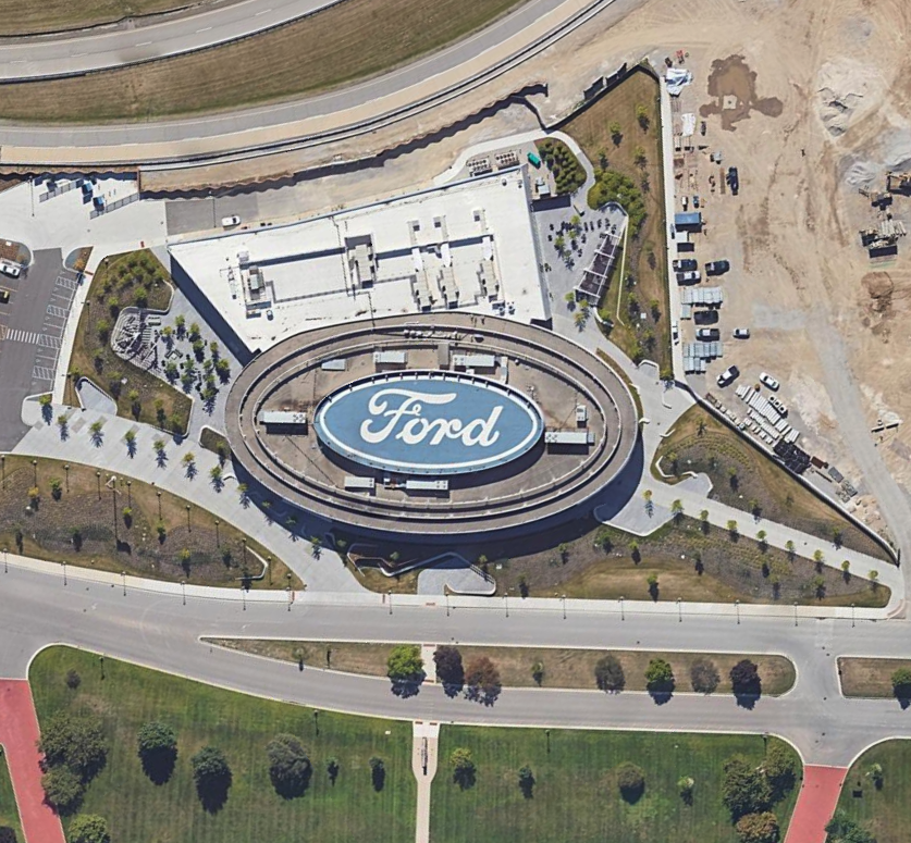
Giant Mattel Logo
The giant logo of Mattel is visible at their headquarters in El Segundo, California.
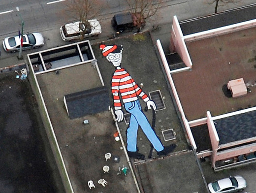
Where’s Waldo in Google Maps?
Canadian artist Melanie Coles built a large image of the iconic “Waldo” onto a rooftop at an undisclosed location in Vancouver, British Columbia, Canada.
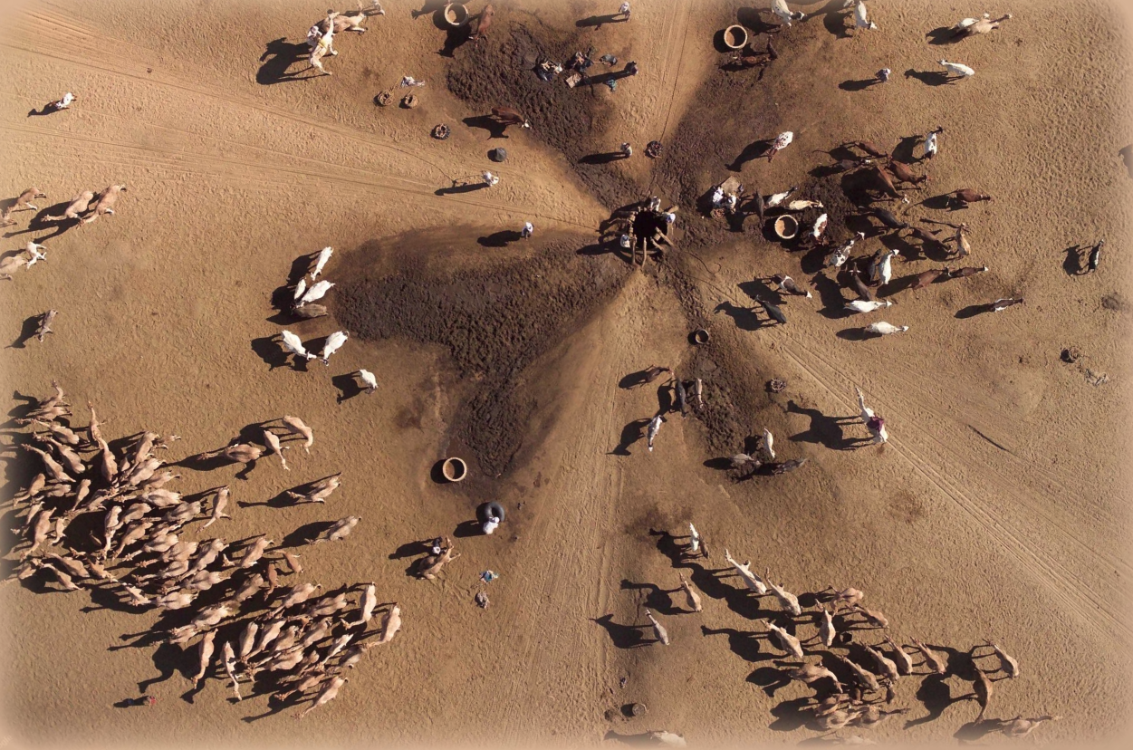
A Water Break in Nigeria
Humans and camels gathered together at a water source in Nigeria.
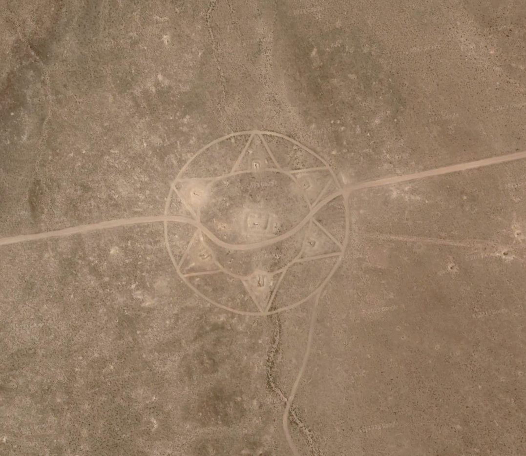
Crop Circles
Without a doubt, the best thing that ever happened to crop circles is Google Earth. This circle in the desert just outside Beatty, Nevada.
Portrait of Ghenghis Khan in Google Maps
Out of some sort of fear that they might forget who he was, the people of Mongolia have carved the likeness of Ghenghis Khan onto a hillside outside of Ulaanbaatar.
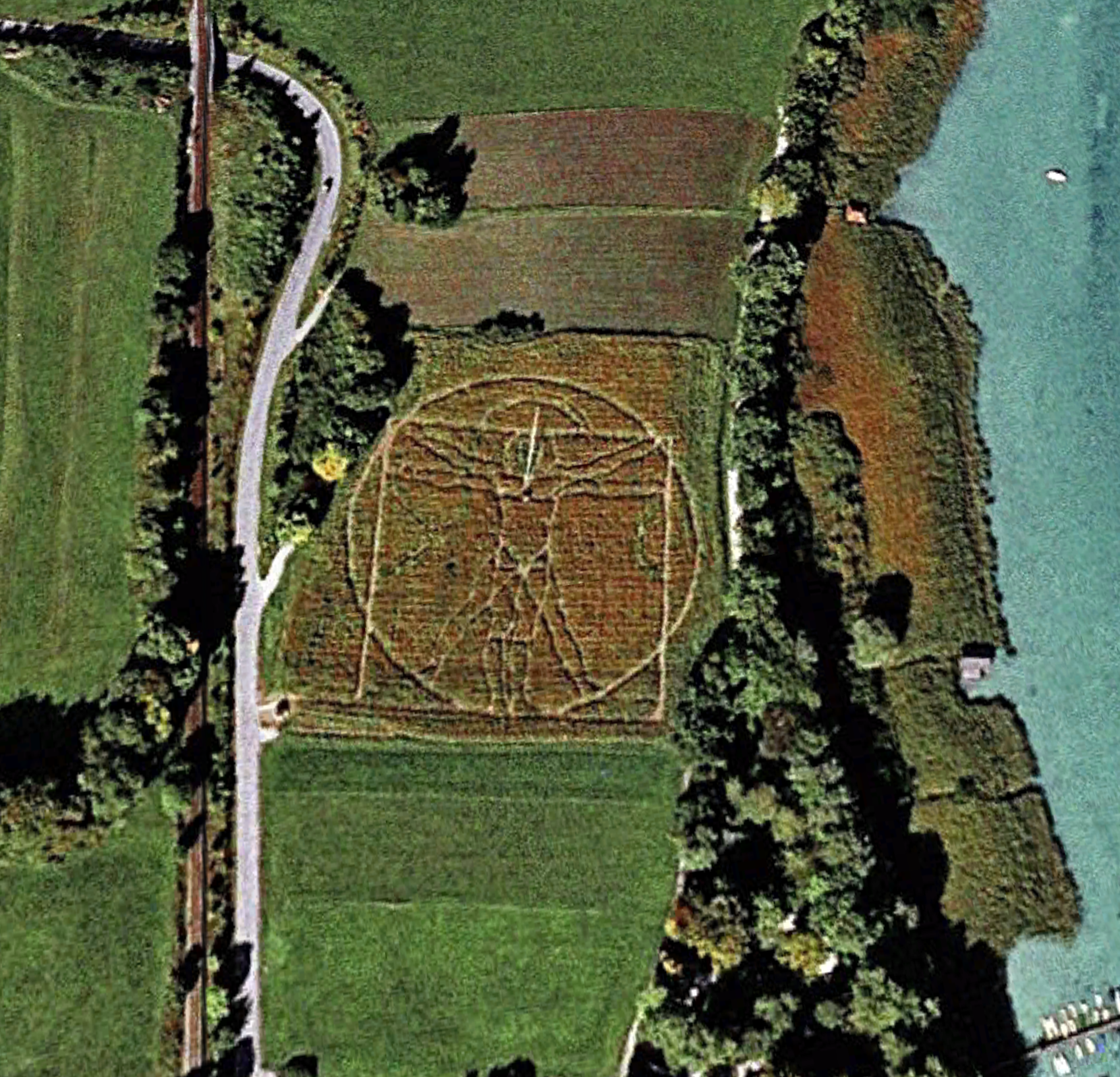
The Vitruvian Man by Da Vinci
Leonardo da Vinci’s Vitruvian Man – one of the world’s most recognizable illustrations – is rendered here in crop art in Germany.
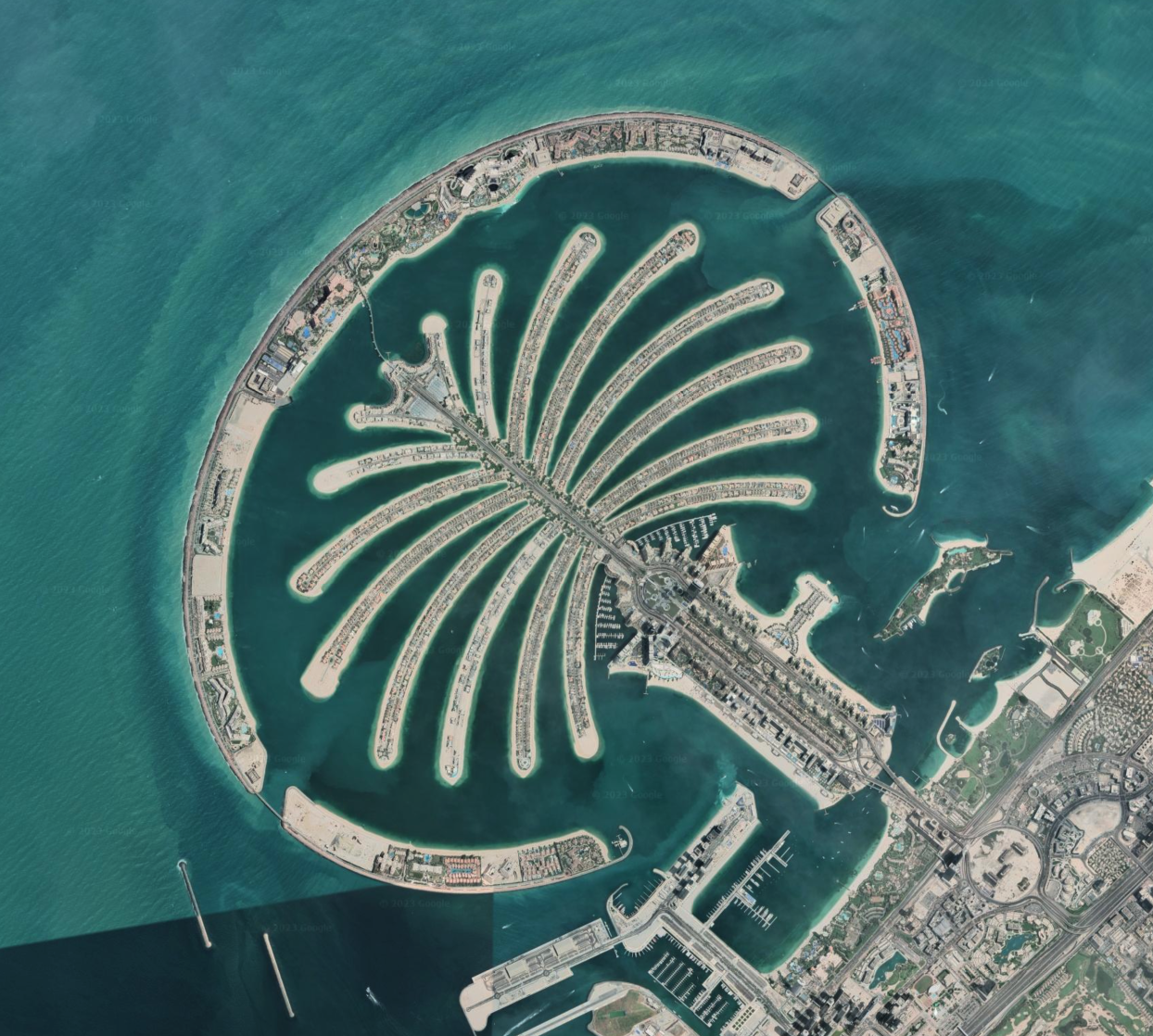
The Palm Islands of Dubai
The Palm Islands are artificial islands in Dubai, United Arab Emirates on which major commercial and residential infrastructure will be constructed. They are being constructed by Nakheel Properties, a property developer in the United Arab Emirates, who hired Belgian and Dutch dredging and marine contractor Jan De Nul and Van Oord, some of the world’s specialists in land reclamation. The islands are the Palm Jumeirah, the Palm Jebel Ali and the Palm Deira.
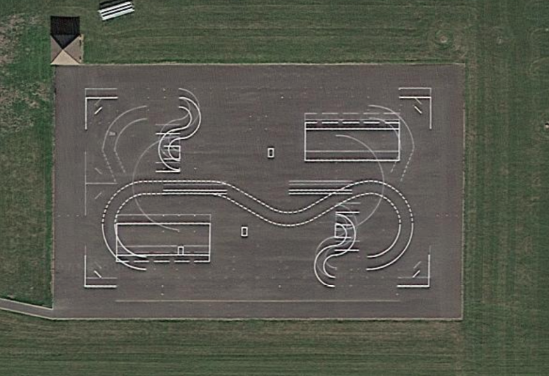
Motorcycle Range or UFO Landing Tracks?
There are bizarre structures discovered on U.S. and British air bases, such as this one located near Norwich in England. The area has been deemed a motorcycle range by the U.K. Ministry of Defense, though some believe it could potentially serve as a calibration mechanism for satellites.
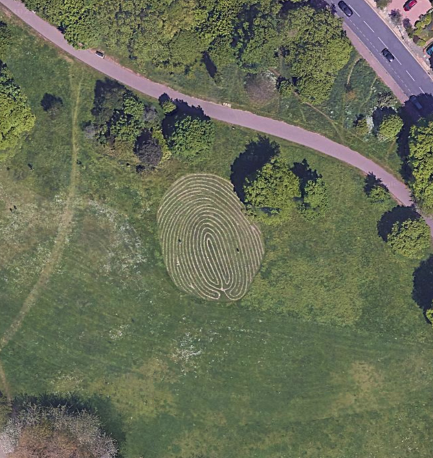
World’s Largest Fingerprint
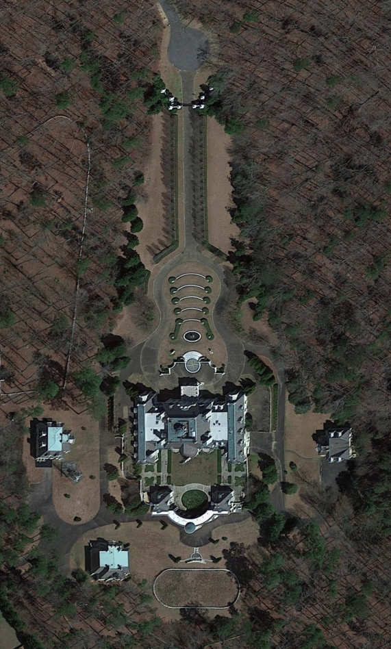
Guitar-Shaped Mansion
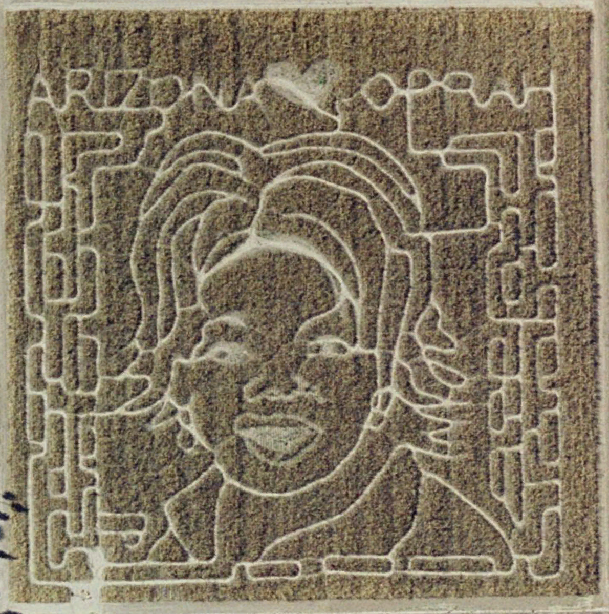
Oprah Maze
She’s got a massive syndicated show and a magazine called O, and she was dubbed the most powerful celebrity in the world by Forbes. Why shouldn’t Oprah get her own corn maze? An Arizona farmer created this 2004 tribute to the TV talk-show host.
Mystery Stone Arrow
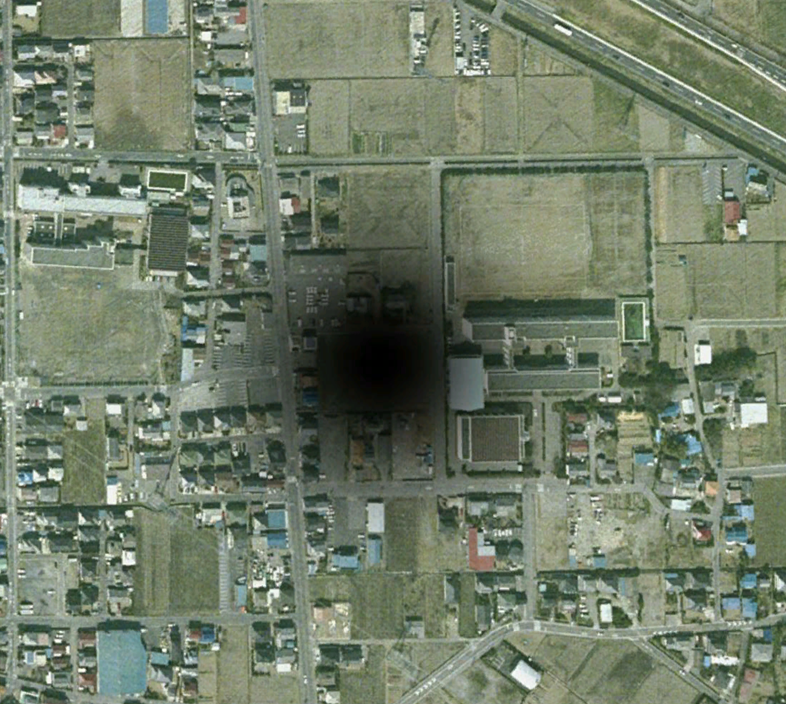
Localized Black Hole Discovered
As we all know, the general theory of relativity states that a black hole is a region of space from which nothing can escape – including light. Astronomers have identified lots of places where black holes may exist, but apparently they missed one – about 60km north of Tokyo.
Show Me a Sign
KFC space logo
Yum! Brands Inc created the logo near Rachel, Nevada, and claimed it’s the first ad that can be seen from space. If you recall, the same company had previously wanted to beam a laser ad up onto the moon for Pizza Hut, but had later scaled back to buying ad placement on the side of a Russian rocket.
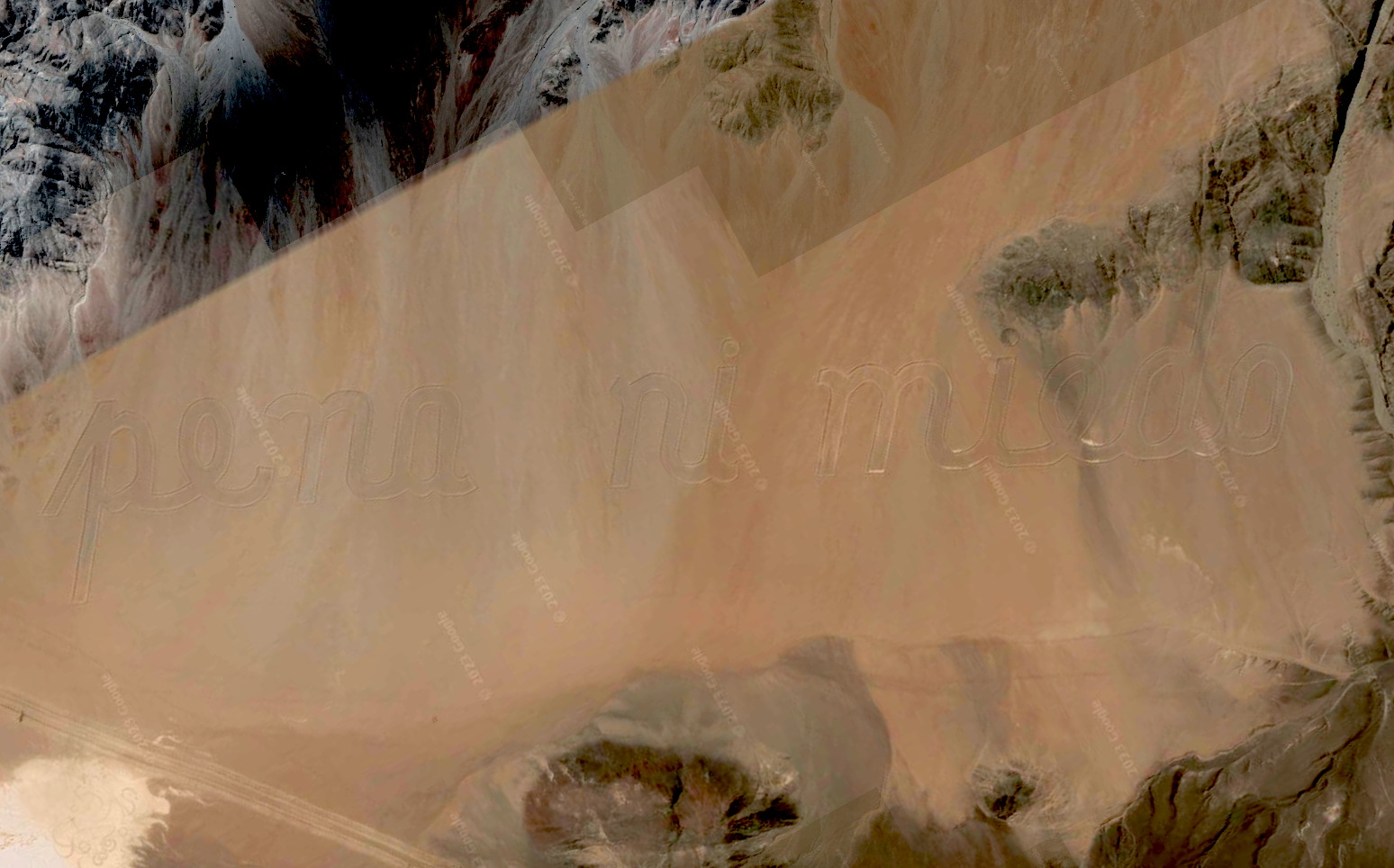
Ni Pena Ni Miedo (No Shame Nor Fear)
Written in the sands of the Atacama Desert, Chile, are the words “ni pena ni miedo” which translate more or less as “No shame nor fear”, and together they form what must surely be the world’s largest poem.
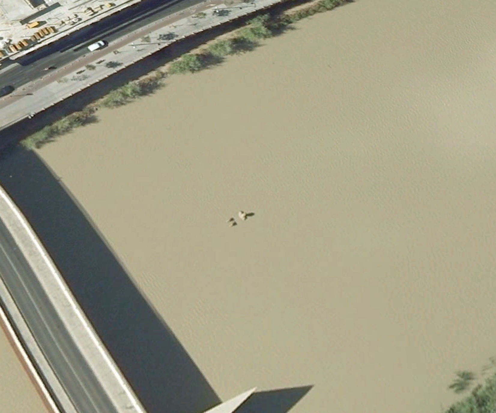
Giant of Córdoba takes a bath
Giants have a hard time getting clean. I mean, baths aren’t usually built big enough to fit your average giant, right? Which is the only sensible explanation as to why there’s a giant sitting in the Guadalquivir river in Córdoba, Spain.
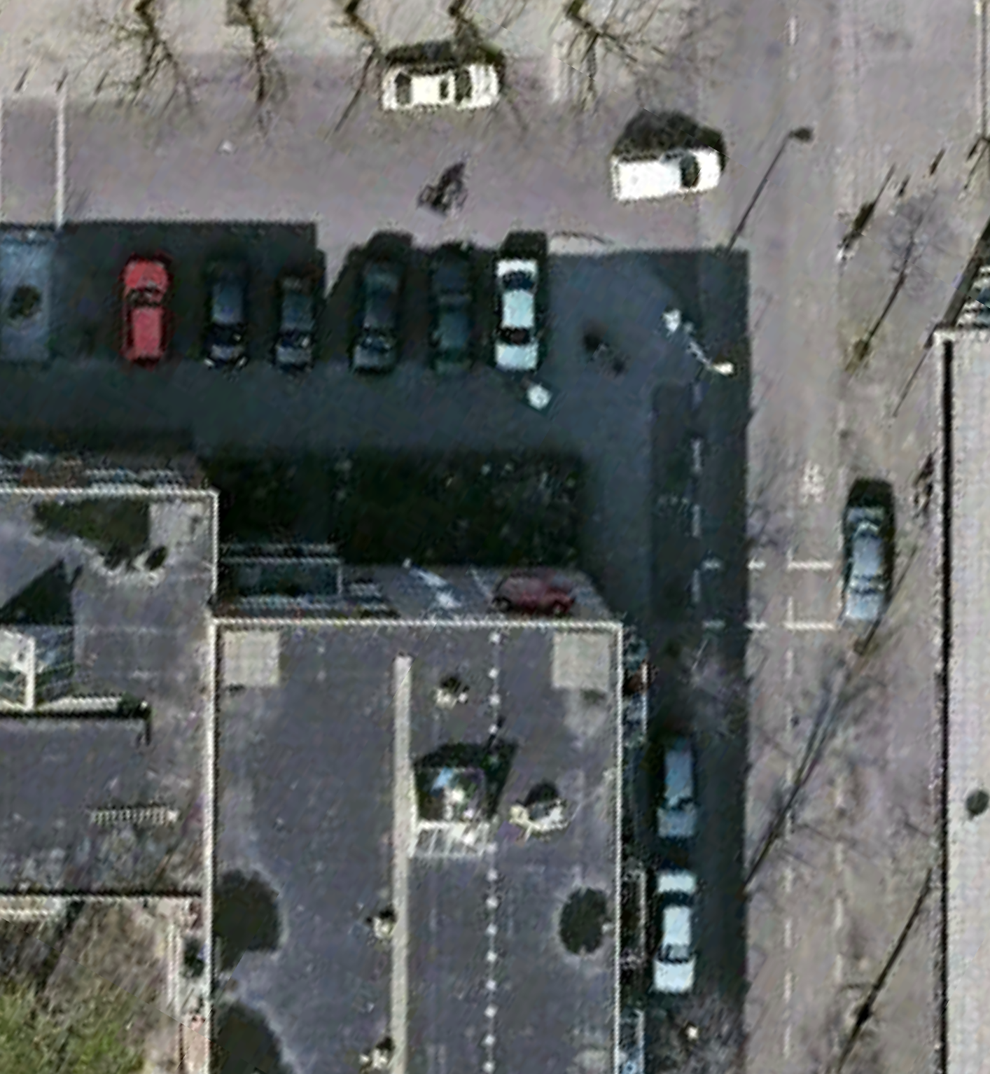
Auto Antics
Think parking is tough where you live? In Westenbergstraat, Netherlands, drivers apparently have to park on the sides of walls.
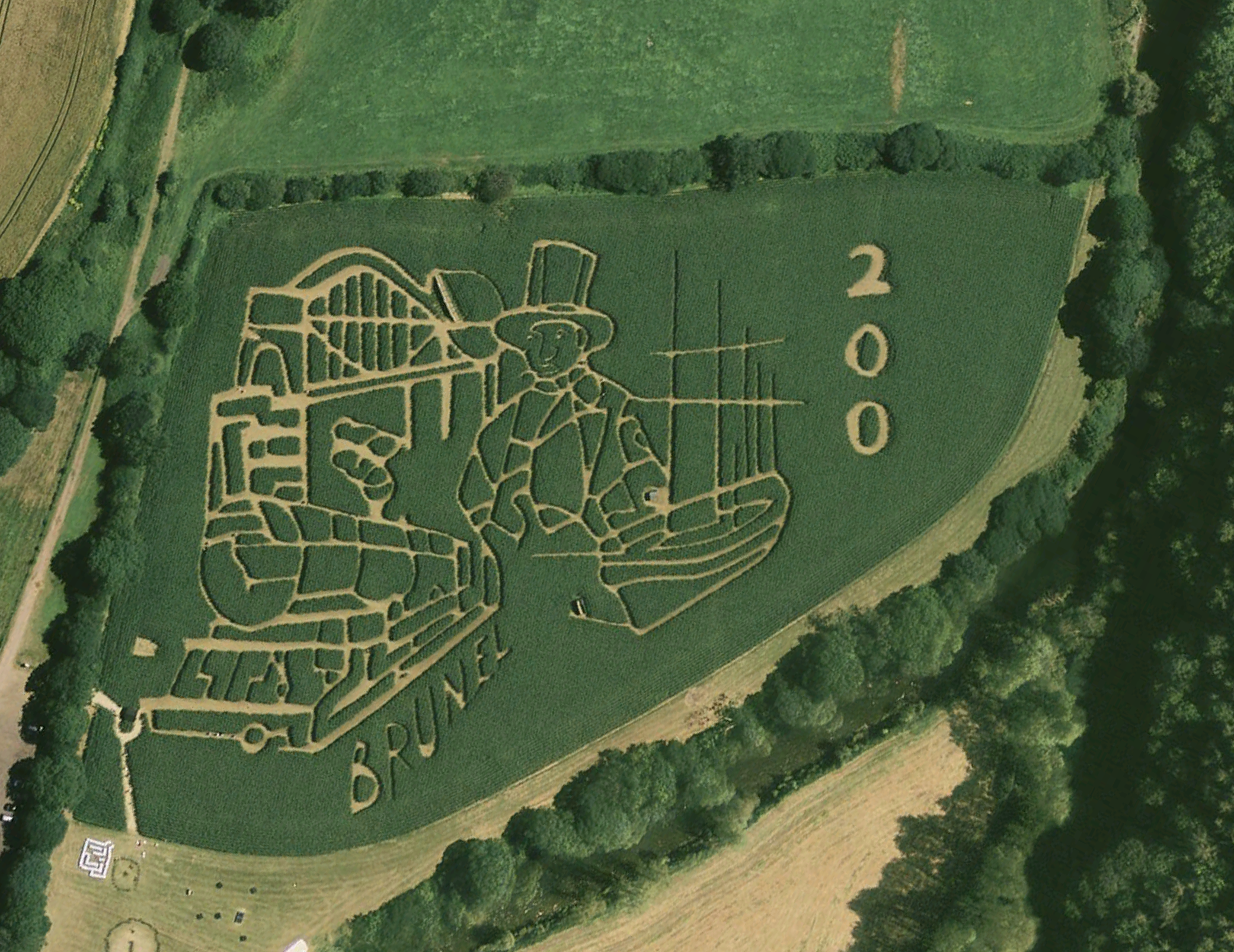
Brunel 200th Birthday Maze
This maze in the UK was made to celebrate Brunel’s 200th birthday.
Land Art – Bug in Illinois
Effigy Tumuli, by Michael Heizer, are a few different land art pieces built on Buffalo Rock in Buffalo Rock State Park, overlooking the Illinois River. (Built between 1983-1985) The animal shapes are barely visible now from satellite pics, though you can see the beetle or roach shape outline in this screengrab.
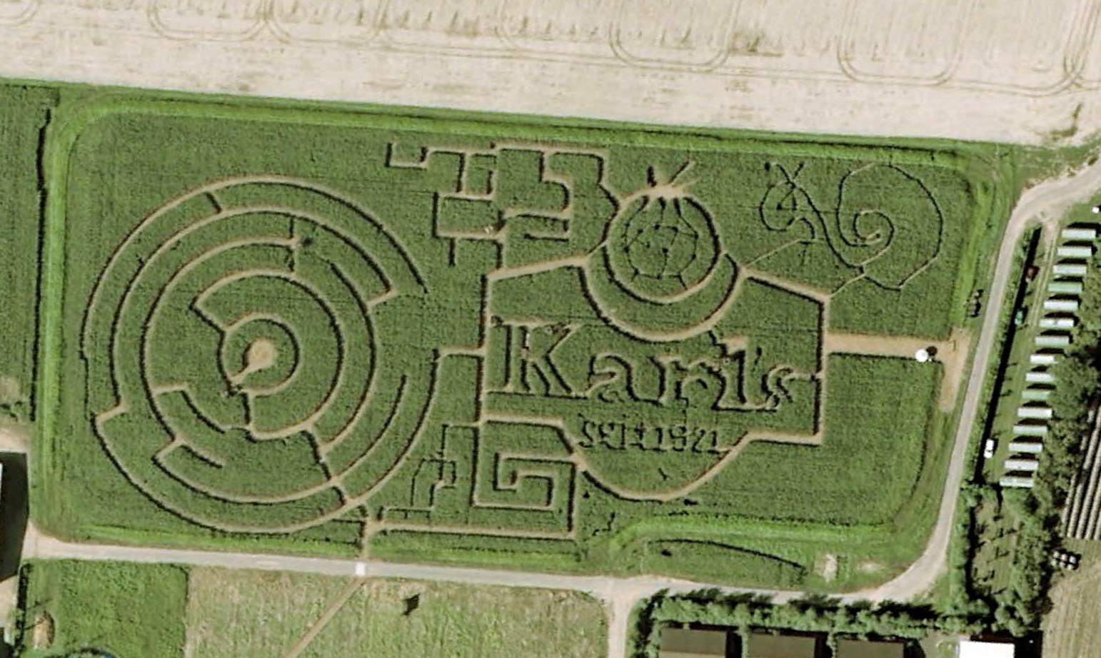
Karl’s Maze, Germany
Karl’s Maze in Purkshof, Germany. Since 1921?


Send Comment:
77 Comments:
130 days ago
I hate everything about this
More than a year ago
Just east of Arica, Chile, there are words carved into the sand
More than a year ago
THIS IS OKAY??
More than a year ago
SUPER strange, but soo cool
More than a year ago
Wow nice??
More than a year ago
The Osmington White Horse isn’t “prehistoric”... it’s from the early 1800’s. *roll eyes*
More than a year ago
How can they make such detailed fingerprints
More than a year ago
Omg I wonder how he got up there to write will you marry me
More than a year ago
I wonder if the girl said yes??
More than a year ago
I have seen two other black holes in the sydney operah house.
More than a year ago
Hey, I like the one with the red stuff on it
More than a year ago
Great post.
Just one correction. "Ni pena, ni miedo" stands for: no sorrow or fear. Not shame or fear.
Thanks and i hope you can find more...
More than a year ago
the Kfc logo is real. u can see it on google earth if you open history and go back in time.
More than a year ago
Cool pics! I'll have to look for some more in GE. :)
More than a year ago
This is a great collection. I was familiar with some of them, bot others were new to me. Thanks for sharing!
P.S.: Did the girl from the first picture say "yes"?
More than a year ago
Check out this "geographic" slashing that was done through the MN DNR. It's cool to look at historic imagery to see how in the 1990's this land was logged off, then grew in, then the surrounding trees were logged off a few years ago.
48º30.49"N 94º50'59.94"W
More than a year ago
The KFC picture is totally made by KFC themselves for advertising purposes.
More than a year ago
How about a plane flying underwater?
More than a year ago
It would be great if someone would create an American flag that could be seen like this.
More than a year ago
Awesome Collection.
Nice to know. Thanks
More than a year ago
all of these exept from the kfc is real and the crop circle is not a crop circle it is a bombing site from the 50s and you forgot the face in the desert somewhere near chile i think. where ever it is it does exist and check out 46 miles hill view it is the house next to the red car to the left
More than a year ago
The photo of the so called "crop circle" near Beatty NV is not a crop circle. It is in the middle of the Nevada testing range near Groom Lake (Area 51) and it is an old bomb storage unit. This is how bomb bunkers were set out in a circle back in the 50's.
More than a year ago
how do you find the KFC logo?
More than a year ago
My recent project, which may be a candidate for your collection.
Regards,
Larry
More than a year ago
Actually they are both real. Why would Google go to the effort of photoshopping that crap then uploading it?
More than a year ago
The KFC pic IS a fake. Some wierdos like to get their jollies from supporting the fraud, for some reason known only to them! Go to 37°38'44.89" N 115°45'04.05" W on google earth. Flat, blank desert in Rachel, Nevada, not near Rachel. If you like this kind of follow up, I'm sure that you'll find a few more fakes listed on this page.
More than a year ago
neat Google Pics...amazing what can be seen from the air...it's a big strange world out there..
More than a year ago
Okay, I took a look at the coordinates for the blood-red sea and it's completely blue now. That pic is either photoshopped or the red was somehow flushed out of the river...
More than a year ago
follow these coordinates 23.809062,5.736151 and you'll see a HUGE skull on top of some random mountain in Algeria. By huge I mean it's at least 10 metters wide.
More than a year ago
The photo of the white horse at Osmington is hardly "pre-historic" as it depicts King George III of England - (1738-1820) - and was designed to welcome him on his visit to Dorset
More than a year ago
Fascinating website. You should include the "Studebaker Trees", a planting of 5000 pine trees at the Studebaker Automobile Co. proving ground in South Bend, Indiana. They've been there since 1937 and spell out the name "Studebaker". Amazing. Google the name to get a fix on the location.
More than a year ago
actually, it's totally real. A few of my friends that go to OSU in Corvallis, Oregon were part of the group that made it.
They spent a lot of time on it.
More than a year ago
I like the I LOVE YOU sign :)
More than a year ago
Wow, interesting! Recommended to share. Most people use Google Earth and most people must know this.
More than a year ago
Well I can see by the volume of comments that people are fairly concerned. Running a blog is difficult because people won't always agree, but that's what makes it so much fun.
More than a year ago
great collection
More than a year ago
Check this out: a fighter jet parked in a back lot in Paris:
More than a year ago
"Will u get away"
Thats exactly what I would say if someone is spying my or watching my house with an helicopter/satelite.
Great colection, that red lake makes me goo creep.
More than a year ago
Nice collection ...
More than a year ago
Simply amazing!
More than a year ago
These are great, they should have done an series of images here in the Southeastern United States of the "See Rock City" barns. They are all over Tennessee and Georgia, maybe a thousand or so of them. It was the parks only form of advertising in the 1950's. Here's the Wikipedia article:
More than a year ago
On the first link (the one to the firefox logo), if you move down a bit you'll see an air plain and 5 cars, 4 forming a cross shape. And beside it what it looks like a bunch of people lying on the floor... wtf is that?! Mob deal gone bad...?
More than a year ago
Nice post... Some interesting things out there :o)
More than a year ago
that giant skelleton is a great piece of art made by the italian artist Gino de Dominicis (he came from Ancona).
Youu can find more news here:
More than a year ago
this is just amazing!
i wonder what we will be able to do next.
thank you for posting!
More than a year ago
I can't believe you missed Murphy's Law:
More than a year ago
Fun seeing stuff from above. Thanks for the post.
More than a year ago
Wow! Amazing photos
More than a year ago
Those are great. There are some very creative people out there.
More than a year ago
On the six pointed star "crop circle"; it's part of a bombing range if you check the source image Zooming out shows bomb craters to the east of the star. Zooming in shows various berms built into the star which are defensive positions. There's some sort of big structure in each of the berms - possibly a type of simulated anti-aircraft missile position. It's not a 'crop circle'.
More than a year ago
actually?I count twice , there only 38 pics in this post???
you may change the number in the title then.
however , nice collection
More than a year ago
Amazing photos!
More than a year ago
Amazing collection. Rooftops, wide fields and huge islands seem to be the new places for advertising, courtesy Google Maps.
More than a year ago
Great invented by people!
More than a year ago
Awesome! I would have been nice if you could have also mentioned the Geo locations. :)
More than a year ago
the neon graveyard in las vegas is neat from the sky:
note the skull from the old treasure island and the m&ms
More than a year ago
that's a lot of earth covered right there...
More than a year ago
Great! Some amazing and some unbelievable.
More than a year ago
Terrific work! loved the heart shaped island but it’s very strange the blood lake.
More than a year ago
Well assembled collection - had not seen many of these before.
More than a year ago
Gosh... this post is such a time waster... spending lots of time looking at these photos.
There goes 10 minutes!
More than a year ago
This is a pretty cool corn maze celebrating a city's centennial.
More than a year ago
been looking for Waldo... can't find him though... =/
More than a year ago
Great collection, Now I am thinking to create something on my house which will appear in next updates of Google Earth. ;)
More than a year ago
really cool collection i like all the pictures...this is very nice work who has done this....Great effort.....:)
More than a year ago
here is the KFC one’s link:
More than a year ago
Come on .. they are not fake you can see there!
More than a year ago
WOOOW!! Such an awesome post! Thank you!
More than a year ago
hey folks,
i miss the nazca lines in peru!
More than a year ago
The Firefox logo is also obviously fake.
More than a year ago
KFC and the red sea.. deffinitly photoshopped
More than a year ago
What a nice pics.
More than a year ago
Great Collection.. Thanks for sharing.
More than a year ago
Did you noticed this giant skelleton ???
More than a year ago
great collection of interesting images.
More than a year ago
awesome collection frd
More than a year ago
Great post, love how people creatively find their way into Google Maps' satellite view. Something I'd love to do, but on a scale like the KFC/Waldo pieces, I don't know where I'd find the time or resources!
One I really like is on the Hawaiian island of O'ahu:
It's the Dole Plantation center, where they have a Pineapple shaped maze.